The grounds · 180 ft · banks, ledges and wrecks
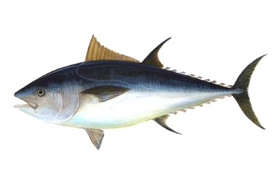
Bluefin Tuna
Thunnus thynnus. Prime water reaches Penobscot Bay in New England right now (59°F at the surface).
LaneThe grounds · 30 fa (180 ft)
Depth it holds82–656 ft
Prime water59–72°F (workable 59–81°F)
Holds in the column33–656 ft down below the surface, over 82–656 ft of water
Judged onsurface temperature (NASA MUR satellite)
Structurenone
The water column off Penobscot Bay
The strip is the water itself, coloured by temperature from the surface down to the 210 ft surveyed bottom at that spot — one band per RTOFS model level. The outlined stretch is where Bluefin Tuna's temperature band (59–81°F) and the depth it holds actually overlap. That thickness is the number that matters: it is how much water you can work, not just whether the spot is warm enough somewhere. One model cycle, not a weekly archive — this holds still while the surface map scrubs.
In 3D
Drag to rotate, pinch or scroll to zoom. 3D model traced from a Unknown authorUnknown author, Public domain reference — source.
How it's fished
Troll, chunk or jig where bait stacks on temperature breaks and ledges.
Region by region — right now
| Region | Season | Prime water | Temp | Fish it at | Months |
|---|---|---|---|---|---|
| New England | in season | reaches Penobscot Bay | 59°F | — | J F M A M J |
| Mid-Atlantic | off-season | reaches Montauk | 67°F | 33–181 ft | J F M A M J J |
"Fish it at" is where this species' temperature band and its holding depth overlap in the water column, from the RTOFS profile (13 levels, 0–300 m) — the depth to actually put a bait, not just the place. "Prime water" is the furthest sampled station on the 30-fathom lane whose surface temperature sits inside this species' band. It is water, not a sighting report.
Charted grounds on the 30-fathom lane